JAGUAR incorporates high-quality built-in maps with station locations. In addition to the standard maps (as part of the main WALLPAPER rotation), JAGUAR can also display several "alternate maps", triggered from TOOLBAR > M (or pressing ALT-M). In this section only the standard MAPS and the related services are described.
The following map continents are available:
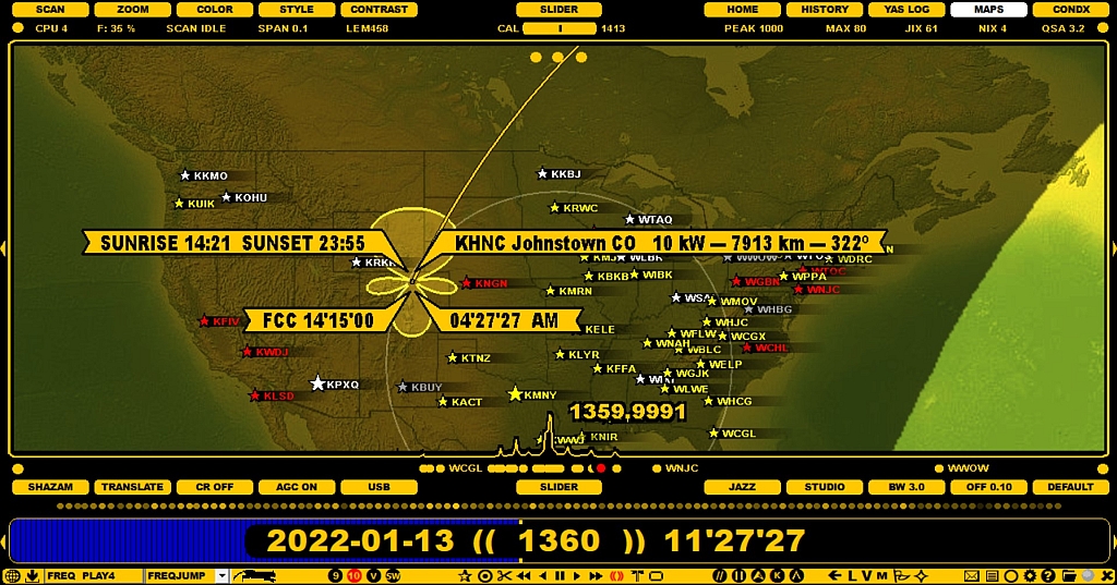
JAGUAR offers three different map styles, the standard "wing" station pointer (a station pointer appears when you hover the mouse over a station) and a special optional station pointer for the U.S. stations. The stations are displayed as stars on the maps, and the station names will appear next to the star, depending on the zoom level. The stars are colored based on your loggings and other notifications. Any map can be zoomed/relocated.
MAPS support additional services for any selected station (see the STATION MENU for details) and the tx patterns for the U.S. stations.
The standard MAPS are an essential part of JAGUAR and they can be accessed in many ways.
MAPS are one of the main wallpapers in JAGUAR, and the main wallpapers can be rotated by pressing the "W" key (the rotation cycle: HOME > HISTORY > YAS LOG > MAPS > CONDX). You also jump directly to MAPS by pressing "M".
When the map window appears, the currently-active continent will be shown. The continents can be rotated with the "Q" key (ALT-Q rotates the "DX areas", but keeps the map continent unchanged), or left/right-clicking or scrolling SLIDER > MAPS. Each map shows the day/night terminator at the time of playback. This terminator is automatically updated during the playback.
JAGUAR offers three different map styles: use SETTINGS > GRAPHICS > MAP_LAYOUT to select your favourite. With SLIDER > CONTRAST you can adjust the darkness of the day/night areas.
When you hover the mouse over a map area, you can zoom the map in/out by scrolling the mouse wheel or using "+" and "-" keys. You can also shift the map's location by using the mouse's drag-and-drop functionality.
If there are MW stations in the visible area of the map on the currently-active frequency, those stations will be displayed with a star on the map. The world map only shows stars, the more detailed continental maps also show station names. The default name shown is the call/short name for each station; full station names will appear when you zoom closer to the desired area.
The stars and names on the map can have different colours, based on user-customizable P-tags (see P-TAGS for more details).
Stations with the transmitter power of 50kW or higher are displayed with a bigger star than the others.
When you move the mouse over a station on the map, by default, JAGUAR will show the following details:
You can select a special station pointer for U.S. / Canadian stations from SETTINGS > GRAPHICS > MAP_POINTER. You can see the local time at the transmitter location, etc. (more in the SETTINGS help).
If you left-click a station star, LOGBOX will appear. LOGBOX can also be invoked by left-clicking a station on the TURTLE database (more details in the LOGBOX help).
If you right-click a station star, the station popup menu appears. It can also be invoked by right-clicking a station on the TURTLE database (more details in the STATION MENU help).
The North America map has three small buttons on the top of the display. Moving the mouse cursor over any of them displays additional information as long as the cursor is kept over the button:
The pattern support requires requires that an additional pattern data package has been installed:
You can exit MAPS by selecting any other display (for example by pressing the "W" key or by pressing the "M" key).